I’ve heard the legends of having to drive to literally everywhere (e.g. drive thru banks), but I have no clue how far apart things are.
I live in suburban London where you can get to a big supermarket in 10 minutes of walking, a train station in 20 minutes and convenience stores are everywhere. You can get anywhere with bus and train in a few hours.
Can someone help a clueless British lemmyposter know how far things are in the US?
EDIT
Here are my walking distances:
- To the nearest convenience store: 250m
- To the nearest chain supermarket: 350m
- To the bus stop: 310m
- To the nearest park: 400m
- To the nearest big supermarket: 1.3km
- To the nearest library: 1.2km
- To the nearest train station: 1km
Straight-line distance to Big Ben: 16km
Oh boy. I used to live in Houston, TX, a city notorious for being car-dependent…
I will present three sets of numbers. First is where I first moved to in Houston, in a supposedly highly coveted, super walkable area home to mostly medical students… Second is the place I lived before I moved out (and I used to boast to people how accessible the place was, by US standards). Third is in Chicago, close to city center (“The Loop”).
And FYI I only lived in places that would be considered to be within the city, so these might be as small as they can get…
- To the nearest convenience store: 900m | 750m | 170m
- To the nearest chain supermarket: 700m(used to be 4.2km) | 450m | 220m
- To the bus stop: 160m(never seen anyone there though) | 350m | 71m
- To the nearest park: 950m | 1.5km | 1.6km
- To the nearest big supermarket: 700m(used to be 4.2km) | 450m | 450m
- To the nearest library: 1.2km | 450m | 1.0km
- To the nearest train station: 7.0km | 3.8km | 2.5km
Fun story about the first location! Everything seems so walkable on paper (close to park, close to highway), until you realize that there was no fucking supermarket anywhere within walking distance… H-E-B only opened a store closeby after I moved there. However, even the super-close grocery store is across the highway and I almost never see any sane people walk there so… For parks I am only counting ones that are good enough to be tourist-worthy, otherwise the latter two locations have pretty easy access to lots of green space
And if you are asking about public transit that are not bus/train: respective distances are 1.4km | 1.0km | 280m. The last number in this series is basically how I chose where to live…
deleted by creator
On the west coast, it can take 14-16 hours to drive from the capital of oregon to the capital of california. Likewise, it takes about as long to get from oregon to montana. It can take 4 to 6 hours to get from the southern oregon border to the northern.
Where I live, i can walk to a little convenience store in about 10 minutes, but the nearest supermarket would be an hour walk away (10-15 minutes by car). If i were to move 10 miles in any direction, i may not have a convenience store around.
Salem to Sacramento shouldn’t take that long unless there is gnarly traffic. As a kid, my family regularly did San Jose to Seattle in 16 hours.
Salem’s not at the northern border. You still have the distance of portland to go, or at least driving around it, and even that can take a while.
From border to border, Organic Maps estimates 5 hours and 20 minutes, which does not include traffic.
I did run the calculation from salem to sacramento though, and i was off by about double. Its 16 hours to southern california (ive done the drive), but to sacramento, its only 8.
The East Coast can be as dense as Europe, because that built up quickly before cars were a rhing. People in cities can walk everywhere, and driving is slower due to traffic
The hills stayed rural and can take forever.
Midwest is the stereotypical America you have to drive everywhere. If you try to walk somewhere in a small town, everyone is going to stop to offer a ride assuming your car broke down
The “fly over” states are giant agricultural farms with nothing in between them. Walking is impossible but you can likely get on a freeway/highway quickly and drive times may be similar to the Midwest, just less options
The west Coast is also densely populated, but happened after the popularity of cars and most cities are designed for cars not pedestrians.
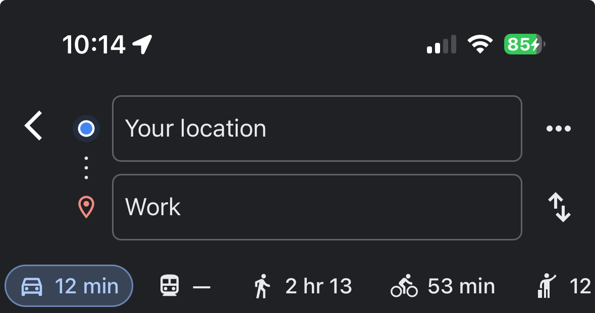
My work commute is minimum 40 minutes one way by car. Probably 2.5 hours by bus, with probably 20 minutes of walking, in Texas heat and humidity.
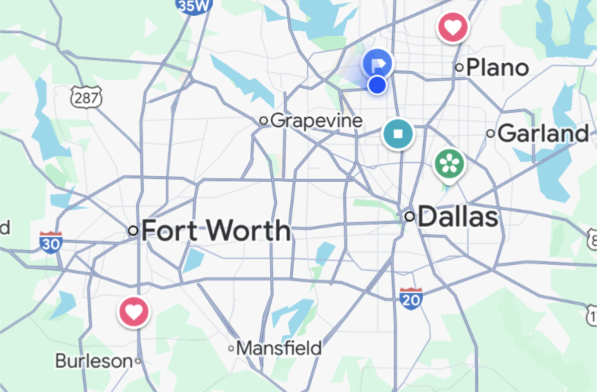
This is a map of the Dallas-Fort Worth (DFW) area in Texas. Yes, we know it looks like a penis. I live near the blue dots at the top right. My husband works near the red heart at the bottom left. That’s about 45 miles and takes an hour most days because both are near highways. Public transit says over 4 hours with three bus/train changes and has a 15 minute walk at each end. Not great when it’s 100F outside.
In many other cities, if you drive 10 miles out of downtown, you can be in the countryside. We can drive 50 miles and be in suburban areas with traffic the entire time. Most people here have a grocery store within 3-4 miles. There are less groceries as you go closer to downtown or in older or cheaper/poorer areas. Convenience stores are closer, but they’re usually gas stations and are pretty expensive for food items. We have several decent restaurants within 5 or 10 miles, but it’s not unusual to drive 20+ miles to go to a favorite restaurant or store or to meet a friend who lives in a different area of town.
In Europe, you can drive for five hours and cross through five cities in three countires. In the US, you can drive five hours and still be in LA.
Let’s give it a shot. I live in the suburbs of Lincoln, Nebraska, which is an average-sized college town in the US (about 300k residents):
- Nearest convenience store: 1.1 miles/1.7km (we often do walk there, takes about 20 minutes)
- Nearest chain supermarket/big supermarket (they are often one in the same here): Target @ 1.5 miles/2.4km
- Bus stop: 1.3 miles/2.1km
- Nearest park: 0.6 miles/965m
- Nearest public library: 3.5 miles/5.6km
- Nearest train station: 9.1 miles/14.6km (we don’t really use trains much at all in the US, though)
I live in DFW, a large amalgamation of two cities and a bunch if suburban sprawl in Texas.
I live in a neighborhood that is considered extremely walkable, as I am directly across the street from a university and less than a mile from city hall.Here are my walking distances:
- To the nearest convenience store: 1.8km
- To the nearest chain supermarket: 4.3 km (They have a monopoly though, so unless you can afford whole foods, the closest good one is like 22.5 km)
- To the bus stop: Lol, we don’t have busses. A neighboring city does, so I guess 29 km?
- To the nearest park: Nearest park is 2.8km. Nearest public space is only 1.5km because I live right next to city hall.
- To the nearest big supermarket: 8.9 km to Walmart.
- To the nearest library: 1.5km, again, I live right next to city hall.
- To the nearest train station: 16km, unless you mean one for intercity travel. We don’t have one of those because Amtrak is slowly being killed.
Straight-line distance to Big Ben: we don’t have a Big Ben, but we killed JFK and that’s 34km away.
Bonus fun fact, I commute 42km each day. This is considered far by most people here, 32km would be much more reasonable.
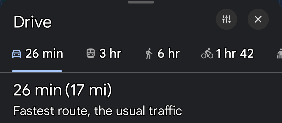
To reiterate how bad public transit is, even in populated areas: I’m also in DFW. This is my daily commute…
It’s ~9.6km. Note that the bus/train option is entirely greyed out, because there is no public transit which runs from my house to my job. If I were to walk, the only option would be on the side of a highway. I would have cars passing me at ~70 MPH without even a curb for protection.
I’m in the Indianapolis area, and we do have public transit… though I don’t know why.
Let’s start with infrastructure.
Buses/metro/any public transit, barriered or not, sparsely or rarely exist. Even painted bike paths/walking paths, these usually exist ONLY in dense or older urban areas. You have either 1-1.5m wide sidewalk elevated 10cm or nothing separating you on foot from car traffic.
So that 250m is often on the shoulder of car lanes.
Now let’s talk property liability. You are responsible for injuries others sustain while on your property unless you have clearly posted signage expressing they were not allowed on your property. Even then and at best you’ll have to disrupt 6mo of your life tied up in courts+fees. (No right to roam. You do get the “perk” of open manhunting season on trespassers)
So that shortcut through the neighborhood where your neighbor laid out gravel because they care about community? Nope, that’s cyclone fence or cinder block wall. That alley between flats? Gated off.
It’s not even scale that’s the problem. You ALWAYS have to go around the ENTIRE block. A 250m Crow flight can easily be and most often is 1+km by foot, and only ever with a curb as your protection from traffic. You can’t safely get to geographically nearby places without putting yourself in mortal danger.
Also note European road design limits traffic in residential areas where the US grid system means every road is a main road and wide enough to promote excessive speeding.
Source: anecdotal/American living in EU
Where I grew up in rural texas: these are current times as I still go there regularly to visit.
Convenience store: 10 km down a major highway
Market: 20 km
The nearest Walmart : 58 km <-- this used to be the only option until they built … The nearest chain grocery: 21 km
Train: 60 km (Amtrak)
Park: 8km. Down a road with a 60 mph (96 km/h) speed limit. But definitely walkable.
Bus stop: ??? There is no public transportation in the town of under 2000 people. Google maps won’t even give me a suggestion so…I have no idea. Does a greyhound count?
Library: 21 km
Username checks out.
I live in a walkable neighborhood in Richmond, Virginia. I have grocery stores in walking distance but usually drive to nicer ones for big hauls. I drive to the gym. I could bike there but there’s no bike lanes and steep hills. Everything else on your list is just a few blocks away.
Just for fun, I decided to check my distances against yours
Here are my walking distances:
- To the nearest convenience store: 1.13km
- To the nearest chain supermarket: 2.74km
- To the bus stop: 33.8km
- To the nearest park: 2.41km
- To the nearest *big* supermarket: 17.7km
- To the nearest library: 2.41km
- To the nearest train station: 24.14km
- Straight-line distance to Nashville’s “The Batman Building” (closest approximation to a large unique cityscape building): 67.76km
I live in a small suburb right outside of a major us city.
To the nearest convenience store: .6 km To the nearest chain supermarket: .9 km To the bus stop: .3km To the nearest park: 1.0km To the nearest big supermarket: .9km To the nearest library: 1.2km To the nearest train station: .6km Straight-line distance to big Ben: 5708 km
You certainly got me on big Ben distance.
But this is why the question is kind of silly. America is a huge, diverse place. When I lived in NYC, I was probably closer to everything than you. Where I grew up in an almost rural area, the closest thing was over 5km away. And this isn’t even all that bad because I had a friend who grew up in an unincorporated area where she had to drive 30min just to get her mail.
- To the bus stop: 33.8km
Is that a typo, or can you just randomly stand at the side of the road and flag down a bus so you don’t need as many formal bus stops?
Because that’s wild.
Haha

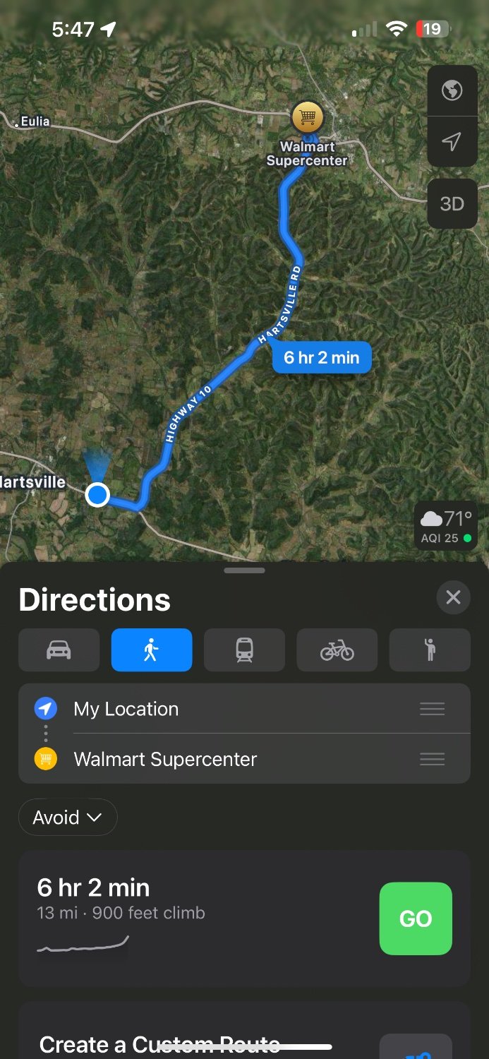
Not a typo. There are no buses unless you go to one of the neighboring cities. I live too far from anywhere that has buses. You either have to walk, or… you can drive! Like everybody else in the US without access to any sort of public transportation remotely close to their home…
Edit: Here’s my nearest walking directions to a large supermarket
I live in a planned community where everything is supposed to be accessible by walking or biking. There are greenway paths all over the place. I generally drive because I can’t carry a weeks worth of food on my bike and most destinations don’t have a safe place to lock your bike up. An unattended bike seems to be considered a free bike.
The only measure on here that matters to most of the US is the Big Ben, and that is only our daily commute.
The US is big.
Meter measures are for rifle shots or bike rides. Maybe runs. It’s not a real measure of travel for us.
Depends.
If you live in a very rural area it can be more than an hour by car to some of these things, 50 miles or more, other items may not exist at all like public transportation. Inter-city public transportation is all but imposable for smaller locations, difficult and lengthy the greater the distance and size differential in locations.
I used to live in a metro area. Everything was within 10 minutes walk except medical care, but walking to the subway would get you to top tier medical facilities in about 15-20 minutes. Getting to nearby “bedroom” communities was also pretty easy thanks to a commuter rail.
I now live in a suburban area that has OK bus service but it’s not very convenient to where I live at all. Everything is within a 10 minute drive, and unfortunately a car is necessary due to the lack of sidewalks in many places. It does have light rail to a major metro area, about two hour’s ride, and then you can access the metro area major transportation network to all nearby areas and further away. Probably about as good as it gets in the US.
Nearest store of any kind - 1 mile
Full serve store - same
Library - .75 mile
Bus stop - 1.2 miles
Small park - .5 miles
Large park - 3 miles
Access to light rail - 4 miles
Knock off this “public transportation is only for big cities” propaganda bullshit. The US literally had a comprehensive rail network. The town of 1000 I used to live in had a train that connected to anywhere in the nation in the 1930s.
I really don’t know what you’re on about. I stated what we have today. Period. My comment has nothing to do with “propaganda” or rail history in the US. Did you even reply to the right comment?
Did you read your comment?
Inter-city public transportation is all but imposable for smaller locations
You took that out of context.
That was intended to mean, as I said, in a modern context. As in you cannot get there via public transportation today. This conversation has nothing to do implementing transportation, this has to do with what we have and how accessible smaller towns are.
So were you looking to be angry or something?
To piggy back off this comment, I’m surprised the streetcars in Kenosha, WI don’t get brought up much for what we could have:
https://en.wikipedia.org/wiki/Streetcars_in_Kenosha,_Wisconsin
It began in June 2000. It was done by doing the municipal equivalent of looking for deals on Craigslist; they bought old cars from larger cities and did a little conversion to get the track gauge right.
Can every small town do this? As it stands, probably not. It depends on larger cities having hand-me-down trolleys, and there just aren’t enough cities doing that for it to work on a widespread basis. But I think it does show that there’s a path to doing this in North American small cities if larger cities can get their shit together.
Far.